
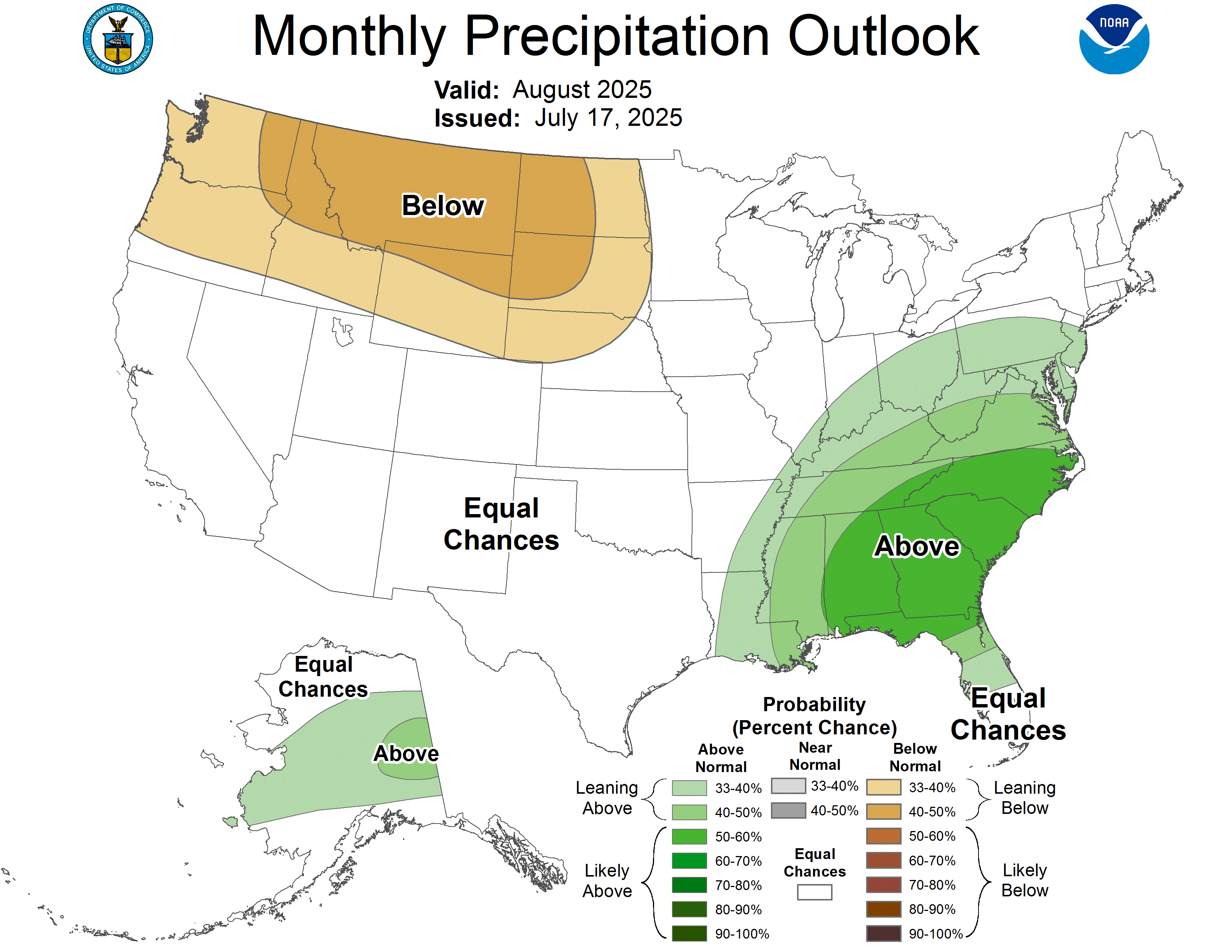
Hier, la NOAA a publié ses perspectives mensuelles pour août 2025. Vous trouverez ci-dessous un résumé pour ceux qui ne connaissent pas la terminologie météorologique et la discussion complète plus bas pour ceux qui le sont.
tl; dr: Pour août 2025, les températures supérieures à la normale sont privilégiées à travers une grande partie des États-Unis, en particulier dans le nord-ouest, tandis que la face sud-est et du milieu de l'atlantique a augmenté les chances de précipitations supérieures à la normale. Les précipitations et les prévisions de température ont une incertitude plus élevée ailleurs, de nombreuses régions ayant des chances égales dans des conditions ci-dessus, proches ou inférieures à la normale.
Perspectives de température
États-Unis contigus (CONUS):
Perspectives des précipitations
Incertitude plus élevée et plus «chances égales» à travers les États-Unis
Discussion complète:
30-DAY OUTLOOK DISCUSSION FOR AUGUST 2025

El Niño Southern Oscillation (ENSO) neutral conditions are present with sea
surface temperatures (SSTs) near average across most of the Equatorial Pacific
Ocean. Recent forecasts from dynamical models  including GEFSv12 and ECMWF
indicate the possibility of a robust Madden Julian Oscillation (MJO) emerging
across the Western Pacific in mid-to late- July. The August 2025 Temperature
and Precipitation Outlooks are based on a combination of dynamical models ,
including CFSv2, the North American Multi-Model Ensemble (NMME), the Copernicus
Climate System (C3S), dynamical models  and statistical tools for the Weeks 3-4
period which cover the early part of August, and potential impacts from the
emerging MJO. Local SSTs and antecedent soil moisture anomalies also
contributed to this outlook where applicable. MJO impacts are weighted
comparatively less as there is still some uncertainty on how the MJO may
progress into August. Impacts from the MJO will be re-evaluated at the end of
the month for the updated version of this Outlook.

The August 2025 Temperature Outlook favors above-normal temperatures across
much of the Contiguous United States (CONUS). The region of highest
probabilities (reaching 60 to 70%) is located over the northwestern quadrant of
the CONUS. Probabilities are increased in this region given higher
probabilities for above-normal temperatures in almost all available tools,
including the NMME, the C3S, CFSv2, positive decadal temperature trends , and
below-normal soil moisture. While tools also agree on probabilities for
above-normal temperature over the East Coast, probabilities are weaker
respectively. Stronger positive decadal temperature trends  over New England and
Florida, along with above-normal SSTs, lead to a weak tilt toward above-normal
(40 to 50%) temperatures. There is less support from trends  over portions of
the Southeast and Mid-Atlantic and probabilities for above-normal precipitation
that may moderate temperatures, thus probabilities are decreased to 33 to 40%
over the area. Weaker but still increased probabilities (33 to 40%) for
above-normal temperatures are also indicated over the Northern Plains and Upper
Mississippi Valley regions. While this above-normal tilt is supported by
decadal trends  as well as forecast below-normal precipitation, most tools had
weaker probabilities over this region, leading to comparatively more
uncertainty. Over Alaska, most tools showed mixed forecasts, particularly over
the central parts of the state where Equal Chances (EC) of above-, near-, and
below-normal temperatures are favored. Positive decadal temperature trends ,
CFSv2, and C3S support a weak tilt toward above-normal temperature
probabilities over the northern coast and eastern parts of Alaska, while
near-normal probabilities are favored over the West, also supported by C3S. An
area of EC is located over parts of the Gulf Coast, stretching northward into
parts of the Southern and Central Plains, Middle and Lower Mississippi Valley,
and Ohio and Tennessee Valley regions. In addition to lower probabilities in
most monthly tools, there is a possibility of cooler temperatures over this
region given the emerging MJO as well as the presence of above-normal soil
moisture which may work to moderate temperatures and decrease confidence. EC is
also indicated over southern parts of the West Coast, where cooler than normal
SSTs and the possibility of seabreezes may lead to cooler temperatures.

There is more uncertainty and disagreement in tools supporting the August 2025
Precipitation Outlook, thus the Precipitation Outlook has more extensive areas
of EC. A tilt toward below-normal precipitation is indicated from the Northwest
Coast to the Upper Mississippi Valley, though probabilities are somewhat low
(33 to 40%) for much of this region given some inconsistencies in tools.
Probabilities reach 40 to 50% where there was agreement between the C3S and
NMME. Tools had better agreement on the chance of above-normal precipitation
over the southeastern corner of the CONUS and parts of the Mid-Atlantic, which
is additionally supported by above-normal soil moisture (toward the western
parts of this region), and chances of storminess and unsettled conditions
leading to possibility of increased precipitation. Above-normal precipitation
is also weakly favored over western Alaska, owing to above-normal precipitation
trend, and stretching across central Alaska to the East Coast, where NMME
models had a modest tilt toward above-normal precipitation.