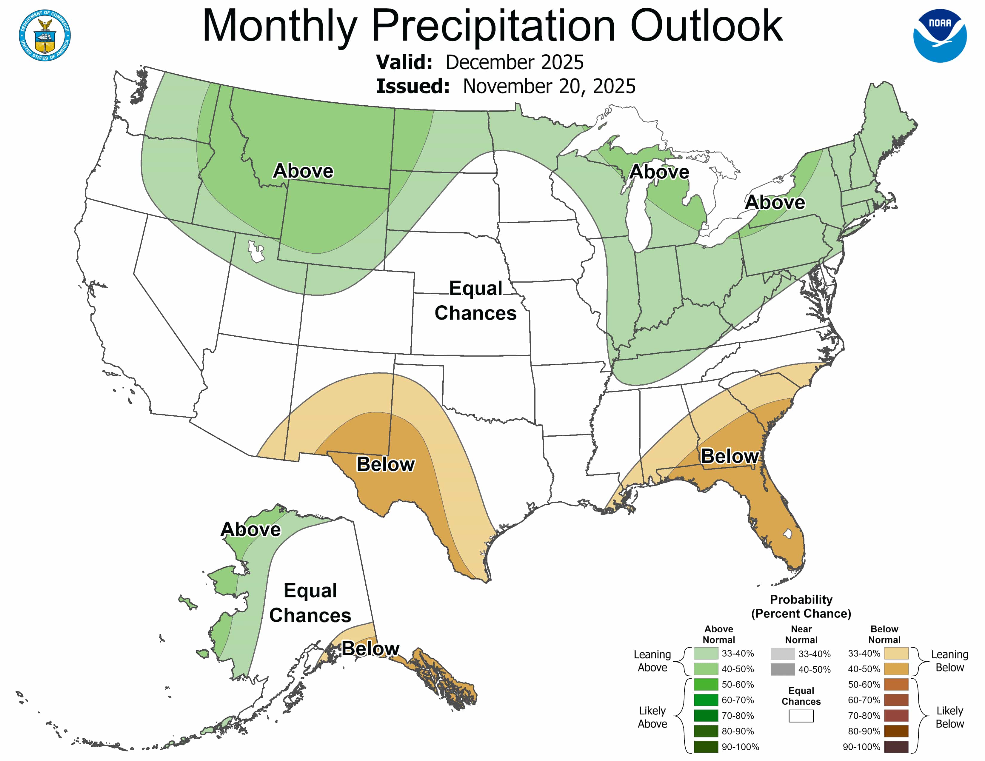
Hier, la NOAA a publié ses perspectives mensuelles pour décembre 2025. Vous trouverez ci-dessous un résumé pour ceux qui ne connaissent pas la terminologie météorologique, et la discussion complète plus bas pour ceux qui le connaissent.
TL;DR – Décembre 2025 semble prometteur pour les stations balnéaires du nord et de haute altitude, avec des températures plus froides que la moyenne et de bonnes chances de neige dans le nord-ouest du Pacifique, dans les Rocheuses du Nord et dans les Grands Lacs. Les zones du sud et de basse altitude, y compris une grande partie du sud-ouest et du sud-est, devraient rester plus chaudes et plus sèches. Cependant, de courtes vagues de froid pourraient améliorer brièvement les conditions en début de mois.
Perspectives de température de la NOAA pour décembre 2025
Ouest des États-Unis et Rocheuses
Centre et est des États-Unis
Alaska
Précipitations et potentiel de neige de la NOAA en décembre 2025
Montagnes occidentales
Chaînes centrales et orientales
Région des Grands Lacs et nord-est des États-Unis : Les signaux de précipitations supérieurs à la normale suggèrent des trajectoires de tempêtes fréquentes et des éclats de neige potentiels par effet de lac lorsque l’air arctique interagit avec les eaux encore chaudes des lacs.
Vallée de l’Ohio : Plus humide que la moyenne ; le potentiel de neige existe principalement au nord de la rivière Ohio, à mesure que l’air plus froid s’épaissit plus tard dans le mois.
Alaska
Ouest et Nord du continent : Plus humide que la normale, améliorant l’accumulation de neige dans les chaînes du nord.
Sud-est de l’Alaska : Plus sec que la normale sous l’influence de La Niña.
Points clés à retenir pour les domaines skiables
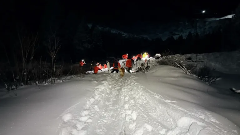
Meilleurs paris pour la neige en début de saison : Cascades, Rocheuses du Nord, Tetons et Grands Lacs du Nord.
Air le plus froid : Probablement dans les États du nord des États-Unis et dans les régions montagneuses si un SSO se développe d’ici le milieu du mois.
Modèle plus variable : Sierra Nevada et Intermountain West, où les changements induits par le MJO pourraient osciller rapidement entre des périodes chaudes et des périodes de neige.
Zones plus douces et plus sèches : Désert du sud-ouest, sud des Rocheuses et sud-est des États-Unis
La discussion complète de la NOAA est ci-dessous :
30-DAY OUTLOOK DISCUSSION FOR DEC 2025

The December 2025 Monthly Outlook was made with ongoing La Niña conditions
expected to continue into winter. The most recent weekly Niño 3.4 sea surface
temperature (SST) anomaly is about -0.7 degrees Celsius. SST anomalies in the
central and east-central equatorial Pacific Ocean remain negative. Outgoing
longwave radiation (OLR) anomalies were negative over the far western Pacific
Ocean, associated with enhanced convection and precipitation over parts of the
Maritime Continent. Positive OLR anomalies, indicating suppressed convection
and precipitation, were present near the International Date Line, consistent
with La Niña conditions. Low-level (850-hPa) easterly trade winds were enhanced
over the western and east-central equatorial Pacific, also consistent with La
Niña conditions. Upper-level (200-hPa) wind anomalies were westerly over most
of the equatorial Pacific Ocean in recent weeks. Negative subsurface ocean
temperature anomalies persisted near the surface in the central and eastern
equatorial Pacific Ocean, increasing the likelihood of persistent La Niña
conditions. Dynamical model forecasts and the CPC El Niño Southern Oscillation
(ENSO) Outlook predict La Niña conditions are most likely to persist for the
December-January-February winter season with a probability slightly greater
than 50 percent. However, La Niña conditions are most likely to end in the
January-February-March season with a probability greater than 60 percent.
Although this La Niña is likely to remain weak and be of short duration,
predictability of the December climate outlook is largely due to current La
Niña conditions.

Recently, the upper-level polar vortex has become displaced from the pole and
elongated over North America. Recent forecasts from the ECMWF model predict
enhanced probabilities of a rare November sudden stratospheric warming (SSW),
and propagation of atmospheric temperature anomalies to the surface in polar
regions, resulting in a negative Arctic Oscillation (AO). Forecasts of the
potential SSW event remain uncertain and change from model run to run. Although
there is still substantial uncertainty, an SSW could greatly impact the climate
outlook for December over North America.

The Madden Julian Oscillation (MJO) has recently been active with enhanced
convection currently over the far Western Pacific Ocean. Dynamical models  such
as the ECMWF predict the potential propagation of the MJO signal eastward into
the Western Pacific. The MJO in this phase enhances the chances of cold air
intrusion into the north-central contiguous United States (CONUS) in early
December extending into the Northeast with time. The combined influence of the
MJO, La Niña, and a possible SSW were considered in the December climate
outlook.

The December temperature and precipitation outlooks were based primarily on
dynamical model and statistical model forecasts. Dynamical model forecasts for
the month of December are from the North America Multimodel Ensemble (NMME). In
addition to the NMME, a consolidation of model forecasts was utilized, which
includes the following statistical tools: the Canonical Correlation Analysis
(CCA), the Constructed Analog (CA), and an ENSO OCN tool, that combines the
impact of ENSO, based on the CPC SST consolidation predicted median Niño 3.4
SST anomaly, with the Optimum Climate Normal (OCN) to represent decadal trends .
Daily initialized forecasts from the Climate Forecast System (CFSv2) dynamical
model for the month of December and the most recent ECMWF and GEFS dynamical
model forecasts for the week 3-4 period that overlaps the beginning of the
month of December were also considered. Recent boundary conditions, including
coastal SSTs, and soil moisture anomalies, were additional factors considered
in the outlook.

The December outlook favors above normal temperatures for the eastern
Aleutians, western Mainland Alaska, and the North Slope, consistent with
dynamical model guidance from the NMME and CFSv2, as well as decadal climate
trends. Below normal temperatures are favored for parts of southeastern
Mainland Alaska and Southeast Alaska, consistent with dynamical model forecasts
from the NMME and CFSv2, as well as the combined impacts of La Niña and the
predicted propagation of the MJO into the Western Pacific. The temperature
pattern over the CONUS in the December outlook is consistent with the La Niña
base state modified by the impacts of MJO and a potential SSW. Above normal
temperatures are favored across the southern tier from California, across the
Southwest, into the Gulf Coast region and Southeast. Probabilities exceed 50
percent over parts of the Desert Southwest and Rio Grande valley, consistent
with recent temperature forecasts from the CFSv2, the consolidation, and
decadal trends . Probabilities for above normal temperatures for this region are
also enhanced by the correlation between predicted below normal precipitation
and above normal temperatures. Probabilities for above normal temperatures over
much of California and Nevada are reduced, due to uncertainty related to an
active MJO and ECMWF and GEFS forecasts for the first half of the month that
show weak signals  over much of the West. Probabilities favoring above normal
temperatures over the Southeast and parts of the Mid-Atlantic coast are
consistent with the impacts of La Niña. Below normal temperatures are favored
for the northern CONUS from northern Washington across the Northern Rockies
into the northern Great Plains, the Great Lakes region, and along the Canadian
border of the Northeast, based on recent forecasts from the CFSv2 model for
December, as well as forecasts for the first half of December from the ECMWF
model. The predicted temperature pattern is largely consistent with the
combined influences of La Niña and MJO propagation into the Western Pacific.
Development of an SSW would substantially increase the probabilities of below
normal temperatures over the central CONUS.

The December outlook favors above normal precipitation for the eastern
Aleutians, western Mainland Alaska, and parts of the North Slope, consistent
with the consolidation of dynamical and statistical model precipitation
forecasts and decadal trends . Below normal precipitation is favored for the
southeastern coast of Mainland Alaska including Southeast Alaska, consistent
with dynamical model forecasts for December, La Niña, and impacts of a Western
Pacific MJO. Above normal precipitation is favored over much of the
northwestern CONUS from eastern areas of the Pacific Northwest to the northern
High Plains, consistent with the CFSv2 forecast for December and the ECMWF
forecast for the first half of the month. Equal Chances (EC) of above and below
normal precipitation is indicated closer to the coast of the Pacific Northwest,
where the December consolidation forecast and the CPC Week 3-4 Outlook indicate
uncertainty in the precipitation signal. Above normal precipitation is also
favored for the Ohio Valley, Great Lakes region, and Northeast, consistent with
dynamical model forecasts for the first two weeks of December and possible
impacts of an active MJO in the Western Pacific and a potential SSW. Below
normal precipitation is favored for eastern areas of the Southwest, including
parts of Arizona, New Mexico and Texas, and for parts of the Southeast Gulf and
Atlantic coasts, consistent with canonical impacts of La Niña and predicted by
the NMME and consolidation forecasts. There is greater uncertainty, indicated
by EC, in the precipitation outlook for California and western areas of the
Southwest.

FORECASTER: Dan Collins